Sci-Fi For Now

“The future isn’t as far off as you think.” Geospatial Technologies have always been crazy futuristic. However, it’s one of those fields that’s almost impossible to reign in as its applications are endless! As long as you’ve got an imagination, and a need, GeoTech is literally what science fiction is made of–for now. It’s becoming […]
The Name Is Mond. DangerMond.

“Jack Dangermond. The Godfather of Geospatial Tech.” We can’t make this up, readers. The man’s name is Jack Dangermond. It stands to reason that he was fated to do something incredible in life. Since we know his name at all, we’re pretty sure he didn’t enter into the life of being a secret spy or […]
GIS and the Covid-19 Crisis
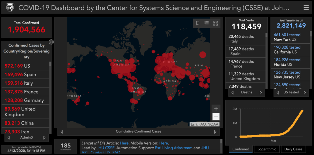
We’ve all seen the population maps tracking the prevalence of positive tests and hospitalizations, but did you know that those were created using GIS technology? Here’s How GIS has helped us track the Covid Pandemic In the beginning of the crisis, information was chaotic and often times incorrect regarding the prevalence and severity of the […]
Geospatial Technologies and Real Estate

Did you know that geospatial technologies are changing the game when it comes to real estate? 4 ways GIS influences Real Estate GIS gives geological information! Did you know that GIS can depict what type of land a house is built on? This is super important for determining if a home is in a flood […]
4 Fun Facts About GeoSpatial Technology
GIS in infancy The beginnings of GIS can be traced to the invention of the first flying machines! Hot air balloons were the first method of aerial imaging, soon followed by the airplane invented in 1903 by the Wright brothers. Photographs from the sky were used as the first geographic mapping tools! What’s the Weather? […]